At the February 26th town hall meeting at 8pm there will be 4 presentations. A video by Mike Guadagnino and Jim Barry – during the video entitled “An Inside Look of the Park”, different areas in the park are visited and explored and explanations are given as to what the plans are at this point for each specific area. This video will give people a view of the many locations found within the property. The meeting will also feature powerpoint presentations on the proposed BMX Bike Park, Dog Park and Skate Park.
Great White Oak Park town hall meetings have been scheduled for Tuesday January 29th 8:00pm and Tuesday February 26th 8:00pm in the council chambers and will be televised.
Below is the feasibility study/plan and more information pertinent to the meetings:
A feasibility study/plan for a passive recreation park to be developed on the property known as Pleasureland and Mueller’s Park was presented by Mike Guadagnino, along with members of the Environmental Commission and Rec Commission working on this project.
The presentation, at the December 19th Mayor and Council meeting, was to announce that the group would like to hold town hall meetings and get Oakland residents’ input; the dates of the town hall meetings will be forthcoming, hopefully as early as January.
The group is actively seeking input for the property and encourages all to attend the meetings. Below is the Feasibility Study with corresponding images and cost estimates.
Great White Oak Park Feasibility Study/Business Plan
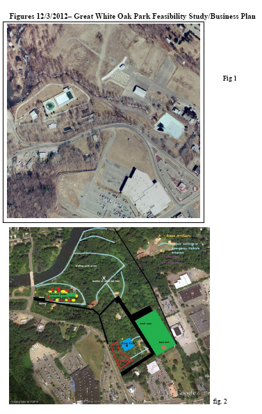 The following feasibility study/business plan has been provided for the purposes of describing the proposed development of the “Great White Oak Park” (Heritage Hills property formerly known as “Pleasure land/ Muller’s Park and FRG). Fig 1 of property at viewed in 1979
Overview/Background:
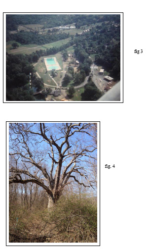
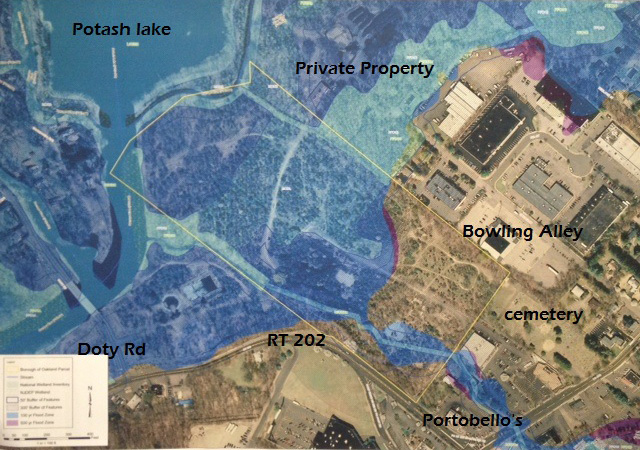
As part of an Open Space initiative, the Borough of Oakland, NJ purchased the area known as “Heritage Hills Property” in 2011. This property was made up of several contiguous land parcels in the northwest corner of Oakland. These areas were for the most part formerly known by names such as Pleasureland, Muller’s Park and FRG. The total land area runs east of the Ramapo River near the Doty Street Bridge and bordered by several other privately held properties along the Ramapo River such as Sandy Beach and the Oakland Industrial Park (see fig. 2.)
During 2012, The Oakland Environmental Commission partnered with the Oakland Recreation Commission to draft an environmentally and financially responsible plan to develop the property for use by the citizens of the borough of Oakland. The plan incorporates low impact development to create a passive recreation area without the need for extensive capital investment in infrastructure, etc. Additionally, discussion has taken place with but not limited to Police, Fire, First Aid Squad, Borough Engineering and Oakland Department of Public Works (DPW) on the impact, DOT feasibility and costs. The goal for obtaining resources for this Development project will be based for the most part, on donations from the public, private grants and organizations interested in sponsoring various areas of the park.
Purpose/Scope:
The purpose of this plan is to describe proposed potential uses of the property and the business plan model for obtaining the resources including finances needed to complete individual portions of the plan. Included in the scope of this plan are environmental impacts along with future maintenance considerations.
Minimizing the environmental impacts of the development is a key goal as well as minimizing the resources needed to develop and maintain the property in the future.
The Plan describes the following:
A) General Description of the Existing Property
Summary of Historical Uses and Aspects
Natural Resources Inventory
B) Listing of Proposed Future Uses/Impacts
Summary Description and Purpose of individual projects
Assessment of Environmental Impacts
Resources needed – Capital Requirements/Budget
Future Maintenance and Financial Impacts
Financial Sources
C) Infrastructure Issues Utilities, Access Points
D) Other Areas of Impact on Oakland Community
E) Development/Market Plan process
A) GENERAL DESCRIPTION OF EXISTING HERITAGE HILLS PROPERTY
The Heritage Hills property is located at (coordinates) in the northwest section of the borough. The property is approximately 40 acres in size. The area is covered mostly in temperate forest trees, low scrub brush under story grassy areas. A small “C-1” stream flows through the area originating from the area near Ramapo Valley Road/Route 202 intersection and meandering to an outflow bordered by the Ramapo River by the Doty Road Bridge, The northwest side of the property is bordered by the Ramapo River to the west and Sandy Beach properties. On the east side the property borders the Oakland Industrial park and properties of several businesses. Several interconnected walking paths and trails are present as well as remnants of buildings and paved areas from prior development and use.
 Summary of Historical Uses and Aspects
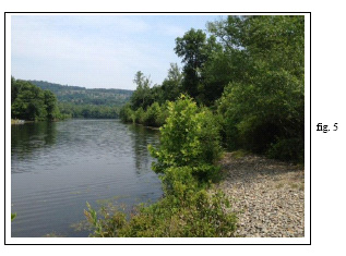
Remains from previous development and uses are still apparent including foundations of buildings which were adjacent to two large swimming pools are in the area known as Pleasureland. (fig. 3 circa 1962). These large pools were filled in several years ago for safety purposes. The concrete bottom of an on older wading/swimming pool in the area of Muller’s Park is unofficially now being used as a skateboard park. Underground pumps for the old pool and old building foundations from several other structures are still conspicuous including concrete pads/foundations of several small buildings near the former pool areas and semi paved parking lots and or roads have become overgrown with grasses etc. Additionally the impact on historical aspects with the most significance is a Native American Indian burial ground the location of which remains confidential to minimize the potential for disturbing the area. The impact on traffic into and out of the proposed park is expected to be very minimal unless there is a planned event with expectations of a large number of people attending.
Natural Resources Inventory:
(Stage I complete, stage II to be performed by the borough this winter)
Proposed name of property is Great White Oak Tree. There is a picture of the tree in fig. 4. The tree is estimated to be a couple hundred years old, is majestic and sticks out amongst all vegetation on park. Keeping with the environmentally sensitive nature of the project, and naming the park after the eldest known object growing, the committee feels the name of Great White Oak Park is a fitting tribute to the borough which is literally translated to Land of the Oak.
B) LISTING OF PROPOSED FUTURE USES AND IMPACTS
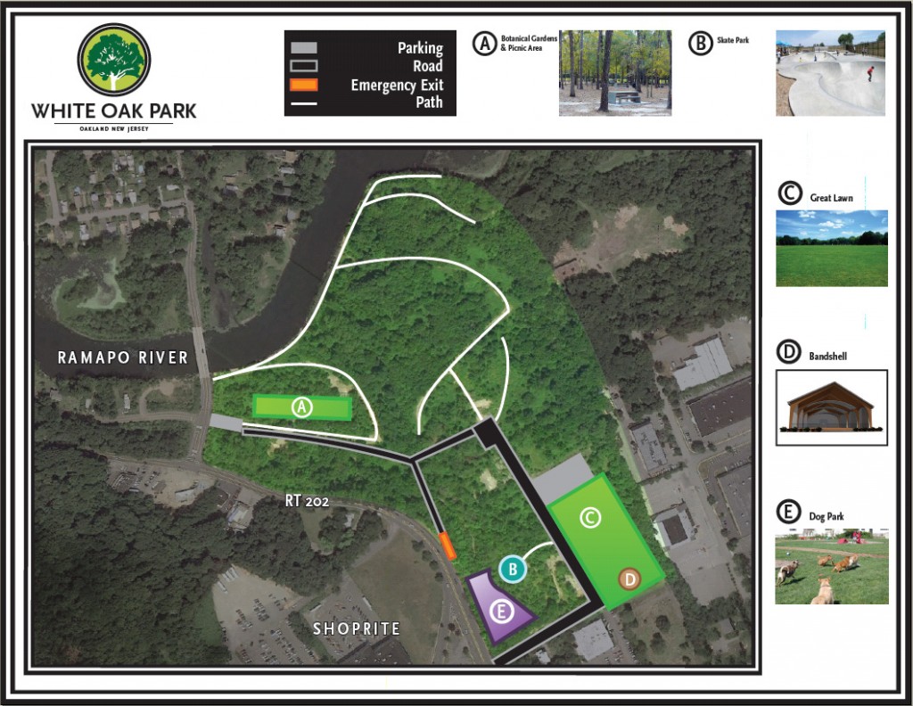
The following represents summarized descriptions of proposed uses and is subject to change. See fig 1 & fig 2 for an overview map of the proposed uses in conjunction with a present day aerial view of the property.
PROJECT SUMMARIES:
1) Proposed Project Name: “Pleasureland Walk” (Acreage between Old Pools, River, Sandy Beach and Large White Oak Tree – fig 4
 Project Champion – Oakland Recreation Commission
Description/Purpose – Walking paths along Ramapo River (fig. 5) and within property with park benches placed along the path’s including facing water along river. Allows for scenic hiking and/or walking with benches to sit and enjoy area and/or rest during walk.
Environmental Impact: Low (no excavation or structures – paths kept in natural state – would require initial clearing of some low scrub along paths)
Resources Needed – Donated Woodchips to expand of several existing undeveloped paths intersecting the property to accommodate emergency vehicles. However most are currently wide enough for this purpose. No plans for lighting in this part of the project. Trail markings and or plaques describing significant historical/past uses could be added.
Future Maintenance – Low (resurfacing annually by volunteer groups using donated wood chips)
Financing – Donations of materials and labor and portion of estimated DPW annual maintenance of $3500
Estimated Budget: Initially $0 future – $500 annually
2) Proposed Project Name: “Boat/Fishing Docks on Ramapo River”
Project Champion – Pleasureland Committee
Description/Purpose -Two docks spaced apart, one closer to Doty Road Bridge and one closer to Sandy Beach property for canoeing (can land and tie canoe to dock) and fishing off dock
Environmental Impact – Must petition DEP because location in flood plain
Resources Needed – Materials and construction for actual dock. Dock must be maintained to ensure safety while accessing river
Future maintenance – Structural integrity
Financing – Donations of Materials. Construction may need to be contracted.
Estimated budget: Pending
3) Proposed Project Name: “Skate Park at Old Mueller’s Wading Pool
Project Champion – Recreation Commission
Description/Purpose –Retrofitting of old wading pool into Skateboard Park, Includes clearing of debris and paths access Skate Park and perimeter
Environmental Impact – Low (small amount construction for paths and safety features inside Skate Park) no additional non-permeable surfaces to be constructed
Resources Needed – Pending
Future maintenance – Structural integrity and maintenance of paths
Financing – Donations of Materials. Any construction may need to be contracted.
Click here for JIF Guidelines being followed in the planning of the Skate Park.
Estimated budget: $32,250 including one-time construction to clear away pool and skate park equipment
4) Proposed Project Name: Jill Schwertfeger Memorial Dog Park
Project Champion – Ryan Schwertfeger
Description/Purpose – Provide an area of approxiemmtately1 acre for dog and dog owners to interact and be allowed to run exercise and socialize in a contained and safe environment. The actual dog runs would consist of two fenced areas approximately 80 x 230 feet and 80 x 150 feet. Project would include paths, benches, and signage
Environmental Impact – Medium (Construction for fencing paths and benches) must be cognizant to remain off flood plain
Resources Needed – Fencing, mulch, labor materials for benches, construction
Future maintenance – Additional mulching and maintenance of paths
Financing – Donations of Materials and resources. Any construction may need to be contracted.
Estimated budget: $ 54,000
5) Proposed Project Name: “Great Lawn Band Shell”
Project Champion – Recreation Commission
Description/Purpose – In area between Mueller’s Drive, proposed parking lot and property line of bowling alley provide an area of approximately 2 acres for a great lawn open space for use for various activities including listening to music or other entertainment from a band shell constructed on the north end near the bowling alley side of the park. Project would include clearing of existing scrub brush, construction of band shell, paths, benches, signage and one time rehabilitation of lawn area.
Environmental Impact – Medium (clearing of brush, construction of band shell running of utilities). Proposal to transplant saplings found during clearing. Return area to original state
Resources Needed – Labor materials for clearing brush, construction of band shell benches
Future maintenance – Additional mulching and maintenance of great lawn and paths
Financing – Donations of Materials and resources. Any construction may need to be contracted.
Estimated budget: $ 56,500 O&R said they would hook-up electricity to band shell at no cost
6) Proposed Project Name: “Botanical Gardens”
Project Champion – Great White Oak Park Committee
Description/Purpose – In the area of the filled in pool areas. Provide an area of approximately 1 acre of open space for use by the Oakland Garden Club for various garden activities including an organic Botanical garden
Environmental Impact – Medium (clearing of brush, construction of band shell running of utilities). Proposal to transplant saplings found during clearing
Resources Needed – Labor materials for rehabilitation soil and construction of deer fencing. Possible need of water source for irrigation
Future maintenance – Additional mulching and maintenance of irrigation, fencing and paths
Financing – Donations of Materials and resources. Any construction may need to be contracted.
Estimated budget: $1000
C. INFRASTRUCTURE ISSUES/ UTILITIES/PARKING ACCESS/MAINTENANCE
Existing Utilities
According to preliminary discussions with Oakland DPW and other borough records, several utilities are already located on the property, including electrical service and water lines. The proposed use of the park will emphasize minimal use of utilities including lighting as the park will be closed at dusk. Existing utility connections will need to be surveyed and requirements for each individual project will need to be evaluated further.
Vehicle Access Points
Access to the area currently is available through several points including one nearDoty Street Bridge and other “unofficial” entrance points near the Holiday bowl, and Portobello Restaurant. Access to areas around the designated C-1 stream needs to be further evaluated to determine if state NJDEP permits are required when renovating any existing structures near these areas. No additional impact on the C-1 stream is being considered at this time, however, in order to provide usable access to various areas for park use and emergency response and security these areas must be improved. The largest single expense associated with this development project is the resurfacing of these previously paved areas as described below.
Presently there is a roadway from Rt. 202 between Mueller’s Park and Portabellos’s Restaurant/house that makes a left upon park entrance and into Mueller’s park. Old parking lots are found at the end of this road. Road to be named Mueller’s Drive.
Driving Access #1: preferred route.
If environmentally feasible drive in from driveway adjacent to Portabello’s Restaurant and house. Drive onto Mueller’s Drive, park in lot areas. When leaving continue towards Doty Road and exit. Mueller’s Drive would be a one way road taking drivers from the Portabello’s area to Doty Rd. Issues are whether there needs to be a second bridge and/or driving accessibility over the C-1 stream, one roadway exist but must be declared engineering safe.
Driving Access #2: if Access #1 is not environmentally feasible and/or may be the initial access until an potential future driving bridges as outlined in Access #1 are approved. Entrance and exit would take place from Mueller’s Drive (starting and ending at area which is adjacent to Portabello’s Restaurant and house). Exit will be a right turn only. Those wishing to turn left onto Rt. 202 would need to make a left onto Plaza Road, then left onto Post Road and proceed to make a left on to Rt. 202 at light. Doty road entrance would allow for small parking area for those accessing the Pleasureland area of the property.
Entrance from Rt. 202 will be right hand entrance only (accessible only from Rt. 202 driving towards Pompton Lakes). Those coming from the other direction will be directed onto Plaza road, make a left onto Post Road and a left at the light which will put them on the other side of Rt. 202 enabling a right hand turn into Mueller’s Drive.
There is an access entrance/exit located on Rt 202 approximate half way between Mueller’s Drive entrance and Doty Road. This entrance/exit has a small road that ends half way between the two parks. This road may be used as an emergency egress/ingress.
Resources Needed – Labor materials for resurfacing and installation of solar lighting and Low wooden parking fences that coral parking area
Future Maintenance – TBD
Financing – Donations of Materials and resources. Any construction may need to be contracted.
Estimated budget: $134,500 to reconstruct roadway and parking lots
D. OTHER AREAS OF IMPACT ON OAKLAND COMMUNITY
1) Historical Areas – The final Development plan will include information with respect to protecting Next to Doty Road and River walk – old Pleasureland swing set
-Just off old pools closer to walking paths – floor of Pleasureland First Aid Squad
-Towards end of Mueller’s Drive closer to Rt. 202 – old floor to building
-Next to skate park – Mueller’s Park pool shed
-Area over Pleasureland Pools
-Poles located in walking trails – Mueller’s Park golf driving range
A) known historical areas and artifacts on the property these include the following Historical An area known to be Native American Burial Ground
B) Other Areas of significance:
2) Traffic Impact discussed with Oakland Police and Fire. Roads to be at least 25ft wide to accommodate emergency vehicles. Traffic effects as posted above under part C Driving Access.
Great White Oak Park town hall meetings have been scheduled for Tuesday January 29th 8:00pm and Tuesday February 26th 8:00pm in the council chambers and will be televised.
Below is the feasibility study/plan and more information pertinent to the meetings:

How about reviving the Bicycle pump track like the one in West Milford that opened up in the fall. That has been a huge success. You definitely have the space now. Stop by Pedal Sports to discuss or talk to Steve Wagoner.
Thanks
If a skatepark is included, it will mean a whole lot to all the kids that skateboard including me …give us a place to go instead of in the center of town getting harassed by police for doing so…it really will mean a lot
On Saturday afternoon (Feb 2) my wife and I walked through about 60% of the property and were very impressed with the amount of space there is to enjoy. There is a lot of work to be done just to clear walking trails of down trees, but nothing a bunch of volunteers and wood chippers can’t handle. In the 45 minutes we walked the property we encountered a dog walker and a couple walking with three young children. Great to see people using the park already!
As a former resident, I like the plan of multi-use without commercialization. Having a “great lawn” and bandshell along with walking trails is a wonderful repurposing of what holds so many memories for us…